Application Description
The GPS Map Camera App seamlessly integrates camera functionality with GPS location tracking. Features like geotagging, GPS scanning, and GPS mapping enable users to create visually rich travel logs. Its robust mapping system displays photos on a GPS map, offering a clear visual representation of their journey. Beyond capturing new images, the app allows users to add GPS location data to existing photos, transforming any photo collection into a geo-tagged photo map. Its intuitive design ensures seamless operation with GPS-enabled devices. Whether you're a professional photographer or a casual picture-taker, the GPS Map Camera App is an ideal tool for enriching your photos with geolocation data.
The GPSMapCameraApp boasts six key advantages:
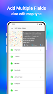
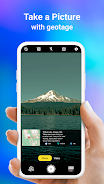
- Integrated Camera and GPS: Capture photos and instantly geotagging them with precise location data, creating a visual travel diary.
- Versatile Photo Capture and Tracking: Take photos with the integrated GPS camera or add geolocation data to existing photos using the app's geotagging feature.
- Powerful Mapping System: Easily visualize your photos on a GPS map, instantly understanding the location of each image within your journey.
- Customizable Date and Timestamps: Add and customize date and timestamp formats to your photos for precise record-keeping.
- Personalized Photo Management: Save photos with custom names and utilize live navigation for effortless organization.
- Lightweight Option Available: A Lite version provides many core features while minimizing device storage usage.
Screenshot


Reviews
Apps like GPS Map Camera App


Trending apps


Top News

![Roblox Forsaken Characters Tier List [UPDATED] (2025)](https://images.dyk8.com/uploads/18/17380116246797f3e8a8a39.jpg)


Latest Apps


Latest Articles