Application Description
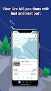
If you're passionate about maritime navigation and vessel tracking, ShipAtlas by Maritime Optima is an indispensable tool that you'll want to have at your fingertips. This powerful app provides real-time AIS position data sourced from over 700 satellites and terrestrial senders, allowing you to monitor vessels and gain insights into trades, port activities, sea routes, marine weather, ice conditions, piracy zones, and marine maps. By collecting raw AIS data for the global merchant fleet every second, ShipAtlas processes this information to deliver high-quality, reliable data to its users. Whether you need to search for specific vessels or ports, calculate sea routes, create vessel lists, set notifications, or access daily marine information, ShipAtlas offers a seamless and user-friendly experience. The app's data synchronization across devices and dedicated support chat ensure that you're always connected and supported.
Features of ShipAtlas by Maritime Optima:
Comprehensive Tracking and Trade Information: ShipAtlas provides users with a wealth of data on port activities, sea routes, marine weather, ice conditions, piracy zones, and marine maps, ensuring you have all the information you need for effective maritime tracking and planning.
High-Quality Data: Through meticulous data wrangling and cleaning processes, ShipAtlas guarantees the accuracy and reliability of the AIS data it collects, giving you confidence in the information you receive.
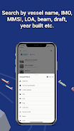
Vessel Search Options: Easily search for specific vessels using their name, IMO, or MMSI numbers, or by port names and types. For even more precise searches, you can use additional details like LOA, beam, draft, and year built.
Sea Route Calculator: The app features an intuitive calculator that quickly provides estimated time of arrival, distance in nautical miles, time at sea, and estimated bunker consumption for various sea routes, helping you plan your journeys efficiently.
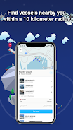
Customizable Vessel Lists and Real-Time Tracking: Create unlimited vessel lists tailored to your search criteria and track these vessels in real-time on the map, ensuring you stay updated on their movements.
Conclusion:
ShipAtlas by Maritime Optima stands out as a user-friendly app that delivers real-time AIS position data and a comprehensive suite of tracking and trade-related information. With its commitment to high-quality data and an intuitive interface, coupled with features like the sea route calculator, ShipAtlas is an essential tool for anyone engaged in vessel tracking. While the basic features are available for free, upgrading to a paid subscription unlocks additional functionalities to enhance your experience. Download ShipAtlas today to dive into the fascinating world of maritime navigation and information. Visit our website to discover more about what ShipAtlas can do for you.
Screenshot
Reviews
Apps like ShipAtlas by Maritime Optima


Trending apps


Top News

![Roblox Forsaken Characters Tier List [UPDATED] (2025)](https://images.dyk8.com/uploads/18/17380116246797f3e8a8a39.jpg)


Latest Apps


Latest Articles